Yukon River
| Yukon River | |
| River | |
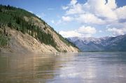
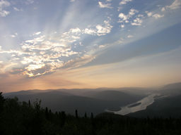 A view of the Yukon River near Dawson City, Yukon
|
|
| Countries | United States, Canada |
|---|---|
| State | Alaska |
| Source | Llewellyn Glacier at Atlin Lake |
| - location | Atlin District, British Columbia, Canada |
| - coordinates | |
| Mouth | Bering Sea |
| - location | Wade Hampton, Alaska, United States |
| - elevation | 0 m (0 ft) |
| - coordinates | |
| Length | 1,980 mi (3,187 km) |
| Basin | 330,000 sq mi (854,696 km²) |
| Discharge | |
| - average | 227,000 cu ft/s (6,428 m3/s) |
| [1][2] | |

The Yukon River is a major watercourse of northwestern North America. The source of the river is located in British Columbia, Canada. The next portion lies in, and gives its name to Canada's Yukon Territory. Then, more than the lower half of the river lies in the U.S. state of Alaska. The river is 3,185 km (1,980 mi)[2][3] long and empties into the Bering Sea at the Yukon-Kuskokwim Delta. The average flow is 6,430 m³/s (227,000 ft³/s).[1] The total drainage area is 832,700 km² (321,500 mi²),[1] of which 323,800 km² (126,300 mi²) is in Canada. By comparison, the total area is more than 25% larger than Texas or Alberta.
The longest river in Alaska and the Yukon Territory, it was one of the principal means of transportation during the 1896–1903 Klondike Gold Rush. Paddle-wheel riverboats continued to ply the river until the 1950s, when the Klondike Highway was completed. After the purchase of Alaska by the United States in 1867, the Alaska Commercial Company acquired the assets of the Russian-American Company and constructed several posts at various locations on the Yukon River.
Yukon means "great river" in Gwich'in. The river was called Kwiguk, or "large stream", in Yupik. The Lewes River is the former name of the upper course of the Yukon, from Marsh Lake to the confluence of the Pelly River at Fort Selkirk.
The Yukon River has had a history of pollution from gold mining, military installations, dumps, wastewater, and other sources. However, the Environmental Protection Agency does not list the Yukon River among its impaired watersheds, and water quality data from the U.S. Geological Survey shows relatively good levels of turbidity, metals, and dissolved oxygen.[4]
The Yukon River Inter-Tribal Watershed Council, a cooperative effort of 64 First Nations and tribes in Alaska and Canada, has the goal of making the river and its tributaries safe to drink from again by supplementing and scrutinizing Government data.
Contents |
Course
The generally accepted source of the Yukon River is the Llewellyn Glacier at the southern end of Atlin Lake in British Columbia. Others suggest that the source is Lake Lindeman at the northern end of the Chilkoot Trail. Either way, Atlin Lake flows into Tagish Lake (via the Atlin River), as eventually does Lake Lindeman after flowing into Bennett Lake. Tagish Lake then flows into Marsh Lake (via the Tagish River). The Yukon River proper starts at the northern end of Marsh Lake, just south of Whitehorse. Some argue that the source of the Yukon River should really be Teslin Lake and the Teslin River, which has a larger flow when it reaches the Yukon at Hootalinqua. The upper end of the Yukon river was originally known as the Lewes River until it was established that it actually was the Yukon. North of Whitehorse, the Yukon River widens into Lake Laberge, made famous by Robert W. Service's "The Cremation of Sam McGee." Other large lakes that are part of the Yukon River system include Kusawa Lake (into the Takhini River) and Kluane Lake (into the Kluane and then White River).
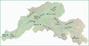
The river passes through the communities of Whitehorse, Carmacks, (just before the Five Finger Rapids) and Dawson City in the Yukon Territory, and crossing Alaska into Eagle, Circle, Fort Yukon, Stevens Village, Tanana, Ruby, Galena, Nulato, Grayling, Holy Cross, Russian Mission, Marshall, Pilot Station, St. Marys (which is accessible from the Yukon at Pilot Point), and Mountain Village. After Mountain Village, the main Yukon channel frays into many channels, sprawling across the delta. There are a number of communitites after the "head of passes," as the channel division is called locally: Nunum Iqua, Alakanuk, Emmonak, and Kotlik. Of those delta communities, Emmonak is the largest with roughly 760 people in the 2000 census. Emmonak's gravel airstrip is the regional hub for flights.
Hazards
Volcanoes near the Yukon River, such as Volcano Mountain in the Fort Selkirk Volcanic Field, may have once partly blocked or at least altered the Yukon River by lava flows. Any future activity in this area could disrupt the course of the river and could have serious impacts on people living or working downstream.
Navigational obstacles on the Yukon River are the Five Finger Rapids and Rink Rapids downstream from Carmacks.
Bridges
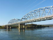
Despite its length, there are only four vehicle-carrying bridges across the river:
- The Lewes Bridge, north of Marsh Lake on the Alaska Highway;
- The Robert Campbell Bridge, which connects the Whitehorse suburb of Riverdale to the downtown area,
- The Yukon River Bridge in Carmacks, on the Klondike Highway; and
- The E. L. Patton Yukon River Bridge, north of Fairbanks on the Dalton Highway.
A car ferry crosses the river at Dawson City in the summer; it is replaced by an ice bridge over the frozen river during the winter. Plans to build a permanent bridge were announced in March 2004, although they are currently on hold because bids came in much higher than budgeted.
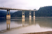
There are also 2 pedestrian-only bridges in Whitehorse, as well as a dam across the river and a hydroelectric generating station. The construction of the dam flooded the White Horse Rapids, which gave the city its name, and created Schwatka Lake.
The river flows into several parklands and refuges including:
- Innoko National Wildlife Refuge
- Nowitna National Wildlife Refuge
- Yukon-Charley Rivers National Preserve
- Yukon Delta National Wildlife Refuge
- Yukon Flats National Wildlife Refuge
Tributaries
Yukon Territory
- Takhini River
- Big Salmon River
- Little Salmon River
- Nordenskiold River
- Teslin River
- Pelly River
- Macmillan River
- Stewart River
- Nadaleen River
- Lansing River
- Hess River
- McQuesten River
- White River
- Donjek River
- Kluane River
- Nisling River
- Beaver Creek
- Donjek River
- Sixtymile River
- Indian River
- Klondike River
- Fortymile River
Alaska
- Tatonduk River
- Seventymile River
- Nation River
- Kandik River
- Charley River
- Porcupine River
- (tributaries in the Yukon)
-
- Miner tributaries
- Fishing Branch
- Bell River
- Eagle River
- Rock River (Yukon)
- Driftwood River (Yukon)
- Old Crow River
- Bluefish River
- Miner tributaries
- (tributaries in Alaska)
-
- Coleen River
- Black River
- Wood River
- Bear Mountain Creek
- Mountain Creek
- Chandalar Creek
- Sheenjek River
- Sheenjek River East Fork
- Koness River
- Eskimo Creek
- Christian River
- Chandalar River
- East Fork Chandalar River
- Junjik River
- Wind River
- Middle Fork Chandalar River
- North Fork Chandalar River
- West Fork Chandalar River
- Marten Creek
- East Fork Chandalar River
- Birch Creek
- Hadweenzic River
- Beaver Creek
- Hodzana River
- Dall River
- Ray River
- Big Salt River
- Hess Creek
- Garnet Creek
- Fish Creek
- Texas Creek
- Coal Creek
- Tanana River
- Nabesna River
- Chisana River
- Tetlin River
- Goodpaster River
- Delta River
- Salcha River
- Chena River
- Wood River
- Nenana River
- Tolovana River
- Kantishna River
- NC Creek
- Tozitna River
- Bluebell Creek
- Dagislakhna Creek
- Banddana Creek
- Blind River
- Bering Creek
- Nowitna River
- Sulatna River
- Big Creek
- Beaver Creek
- Glacier Creek
- Melozitna River
- Black Sand Creek
- Little Melozitna River
- Ruby Slough
- Yuki River
- East Fork Yuki River
- Kala Creek
- Kelly Creek
- Galena Creek
- Bishop Creek

- Koyukuk River
- Workyard Creek
- Gisasa River
- Kateel River
- Dulbi River
- Huslia River
- Nulitna River
- Tom Cook Slough
- Billy Hawk Creek
- Cutoff Slough
- Hogatza River
- Clear Creek
- Batza River
- Matthews Slough
- Little Indian River
- Indian River
- Calamity Creek
- Pocahontas Creek
- Kanuti River
- Discovery Creek
- Alatna River
- Siruk Creek
- South Fork Koyokouk River
- Jim River
- Jane Creek
- John River
- North Fork Koyukuk River
- Nulato River
- Khotol River
- Anvik River
- Bonasila River
- Stuyahok River
- Innoko River
- Paimiut Slough
- Reindeer River
- Iditarod River
- Yetna River
- First Chance Creek
- Mud River
- Dishna River
- Coffee Creek
- Tolstoi Creek
- Madison Creek
- Mastodon Creek
- Hurst Creek
- Taft Creek
- Finland Creek
- Scandinavian Creek
- North Fork Innoko River
- Tango Creek
- West Fork North Fork Innoko River
- Colorado Creek
- Paimiut Slough
- Kako Creek
- Engineer Creek
- Reindeer River
- Atchuelinguk River
- Andreafsky River
- Kashunuk River (distributary)
Geography and ecology
Some of the upper slopes of this watershed (e.g. Nulato Hills) are forested by Black Spruce.[5] This locale near the Seward Peninsula represents the near westernmost limit of the Black Spruce, Picea mariana,[6] one of the most widespread conifers in northern North America.
Yukon River Fisheries
The Yukon River is home to one of the longest salmon runs in the world. Each year Chinook, Chum, and Coho Salmon return to their terminal streams in Alaska, the Yukon Territories, and British Columbia. The Chinook have the longest journey, with an estimated 35-50% bound for Canada. As salmon do not eat during their spawning migration, Yukon River salmon must have great reserves of fat and energy to fuel their thousands-mile long journey. As a result Yukon River salmon are noted for their especially rich and oily meat.
The villages along the Yukon have historically and continue to rely on salmon for their cultural, subsistence, and commercial needs. Salmon are traditionally dried, smoked, and frozen for both human and sled dog consumption. Common methods of fishing on the Yukon include set gillnets, drift nets, dip nets, and fish wheels. The preference of certain gear is largely dependent on the river's varied characteristics in different areas. Some parts of the river do not have eddies to make set-nets successful, whereas in other places the tributaries are small enough to make drifting impractical.
Over the last 20 years salmon recruitment, the number of returning adults, has taken several shocks. The late 1980s, 1990s, and 2000s have been marked by radically reduced runs for various salmon species. The United States Department of Commerce issued a Federal Disaster Declaration for the 2008 and 2009 Commercial Chinook Yukon River fisheries, citing the complete closure of commercial fishing along with restrictions placed on subsistence fishing. The root cause of these poor returns remains debated, with questions about the effects of climate change on ocean food-supply & disease prevalence in returning adults, the methods of fishing used on the river, and the effects of the Bering Sea Pollock trawl fleet on food supply and salmon bycatch [7] [8]. In 2010, the Alaska Department of Fish & Game's Board of Fisheries issued the first-ever restriction for net mesh size on the Yukon, reducing it to 7.5 inches [9].
Various organizations are involved to protect healthy salmon runs into the future. The Yukon River Drainage Fisheries Association was formed in 1990 by consensus of fishers representing the entire drainage in response to recent disaster years. Its organizational goals include giving voice to the village fishers that have traditionally managed these resources, enabling communication between fishers and fishery managers, and helping to preserve the ecological integrity of salmon runs and local cultures' Traditional Ecological Knowledge [10]
In March 2001, the U.S. & Canadian governments passed the Yukon River Salmon Agreement to better manage an internationally shared resource and ensure that more Canadian-originated salmon return back across the border [11]. The agreement is implemented through the Yukon River Panel, an international body of 12 members, equal-parts American and Canadian, that advises managers of Yukon River fisheries concerning restoration, conservation, and coordinated management [12].
Tribal organizations such as Association of Village Council Presidents (AVCP), Council of Athabascan Tribal Governments (CATG), and Tanana Chiefs Conference (TCC) work to sustain Yukon River salmon to promote healthy people, cultures, and communities.
See also
- List of Alaska rivers
- List of Yukon rivers
- Steamboats of the Yukon River
- Alaska salmon fishery
References
- ↑ 1.0 1.1 1.2 Brabets, Timothy P; Wang, Bronwen; Meade, Robert H. (2000). "Environmental and Hydrologic Overview of the Yukon River Basin, Alaska and Canada". United States Geological Survey. http://pubs.usgs.gov/wri/wri994204/pdf/wri994204.pdf. Retrieved 5 March 2010.
- ↑ 2.0 2.1 "Yukon River". Encyclopædia Britannica Online. http://cache.britannica.com/EBchecked/topic/654842/Yukon-River. Retrieved 6 March 2010.
- ↑ Yukoninfo.com
- ↑ USGS Water Quality Samples - 1 sites found
- ↑ Scott R. Robinson. 1988. Movement and Distribution of Western Arctic Caribou Herd across the Buckland Valley and Nulato Hills, U.S. Bureau of Land Management Open file Report 23, Alaska
- ↑ C. Michael Hogan, Black Spruce: Picea mariana, GlobalTwitcher.com, ed. Nicklas Stromberg, November, 2008
- ↑ Thiessen, Mark. Feds declare fisheries disaster for Yukon River. Fairbanks Daily News-Miner. Retrieved 15 March 2010
- ↑ Hopkins, Kyle. Pollock vs. salmon bycatch issue stirs waters at meeting. Anchorage Daily News. Retireved 15 March 2010
- ↑ Associated Press. Fisheries board restricts Yukon salmon gillnets. Anchorage Daily News. Retrieved 15 March 2010
- ↑ Sea Grant Alaksa. Yukon Fishermen Celebrate Ten Years. Arctic Science Journeys. Retrieved 15 March 2010
- ↑ Yukon River Salmon Agreement. March 2001
- ↑ Bylaws of the Yukon River Panel Society. November 2002
External links
- Canadian Council for Geographic Education page with a series of articles on the history of the Yukon River
- The Yukon River Bridge at Dawson City
- [1] "Experience Alaska's Yukon River & the Nowitna National Wildlife Refuge" at "Yukon River Lodge"
- Yukon River Inter-Tribal Watershed Council
- Yukon River Drainage Fisheries Association
- Yukon River Panel
|
|||||||||||